


Plug-in Development:
We were instrumental in the initial development of plug-in architecture. Today, we continue to refine capabilities under current funded efforts, helping with TAK extensibility. The plug-in architectures for ATAK and WinTAK make it easy for third parties to enhance and extend the core product for end users, tailoring TAK to meet specific uses.
TAK Training:
- TAK Fundamentals
- Plugin Development
- Trail Blazer – Route Planning
- sUAS integration and usage
- TAK Server Installation and Administration
- Device Integration including tactical radios and peripherals
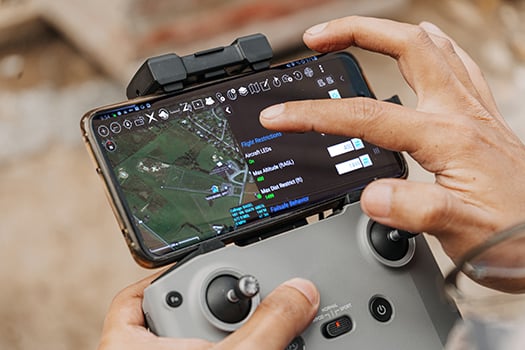
End User Device (EUD) Provisioning:
PGSC’s Android EUD Provisioning capability allows TAK users to receive out-of-the-box, provisioned Android mobile devices with a tactical edition ROM installed and licensed, and includes integration support with tactical radio devices.

Hardware Integration:
Both ATAK and WinTAK take a network agnostic (and vendor agnostic) approach to real-time collaboration. Both solutions are capable of interacting with networks where connectivity is sparse. PGSC's TE-Enabler, an Android App, runs alongside mobile SA Apps like ATAK, providing a comprehensive view of the battlespace. The integrated solution supports interoperability of peripherals Samsung Tactical Edition Galaxy S20 mobile devices. Our solution integrates tactical radios and sensor controls for video sources, even if they don’t share a common network.

Sit(x)®:
Sit(x) is a SaaS solution hosted in the FedRAMP compliant Amazon GovCloud, delivering next generation TAK Server capabilities. It supports federation with GOTS TAK Servers and provides an intuitive user experience allowing organizations to sign up and deploy in minutes.
GvStreamer:
Our GvStreamer product allows users to livestream UAS video, device video, and stationary camera video securely without overcomplicating things. Users can configure access to video sources from within the Sit(x) web user interface.

GV-X:
GV-X displays panchromatic, multi-spectral, hyperspectral, SAR imagery and video, along with related metadata needed for deep analytics. Flexible, resilient and accurate, GV-X out-of-the-box capabilities saves you time, energy, and money.
Push2TAK:
Push2TAK is a feature in which Sit(x) takes your imagery bought from the Data Marketplace and integrates it with the ATAK map on your screen. Images can also be taken and edited/annotated within PAR Government's GVX Product and then integrated into the TAK environment.
Data Marketplace:
Data Marketplace is a method by PAR Government that allows a user to integrate with ATAK via Sit(x) and purchase BlackSky Imagery. Your BlackSky imagery downloads are connected through your Sit(x) account.


Present
2023
2023
2020
PGSC partners with SAMSUNG, delivering S20 commercial Tactical Edition with our TE Enabler. Development continues on TAK Plug-ins.
2019

PGSC extends TAK Navigation capabilities and enhances the sUAS plug-ins.
2019
2018
PGSC works with SAMSUNG to deliver a commercial based Tactical S9 solution. PAR Government focuses on developing an sUAS Toolkit plug-in for TAK.
2016 - 2017

In 2016, with the advent of the WinTAK application, PGSC develops a cross platform environment to share business logic between the ATAK and WinTAK products. During this same year, our team uses cross-platform environment, devloping the iOS Tactical Assault Kit (iTAK).
2016 - 2017
2015

The ATAK application, with mission planning capabilities for mobile users, was extended to a PC architecture with a keyboard/mouse and larger screen real estate. We began development of the Windows Tactical Assault Kit (WinTAK), bringing PC-based capability online, matching capabilities with ATAK.
2014
With the advent of a collaboration capability inside of ATAK, the number of tools centering around connected work began to skyrocket. At the same time, the need to interoperate with other systems on a tactical network increased. To make ATAK more extensible and interoperable, the PGSC team played a key role in developing the plug-in architecture.
2014
2013
With the base growing for ATAK, the need for a sophisticated map rendering engine became apparent. Our team drew from our deep knowledge of processing geospatial imagery, developing a solution that rendered file based and streaming geospatial products to the Android device without requiring external processing.
2012
Network connectivity to ATAK became the goal. The PGSC team was tapped for this project, and members started exploring how to interface Android handsets and tablets with tactical radios.
2012
2010 - 2011

The PGSC team was involved with shaping the original ATAK product as part of a 2010 Air Force Research Laboratory effort. The solution was a mobile android device application for mission planners operating in environments without connectivity. We began contributing our geospatial image processing expertise, helping provide data to a disconnected mapping engine.
Founding